Tornado Touched Down In North Jersey, NWS Confirms Tornado Touched Down In North Jersey, NWS Confirms Tornado Touched Down In North Jersey, NWS Confirms
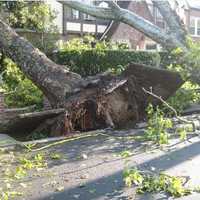
Tornado Touched Down In North Jersey, NWS Confirms A tornado touched down in North Jersey during Thursday's storm, the National Weather Service has confirmed. The EF-0 twister had maximum winds of 65 mph, was 50 yards wide and touched down just before 6 p.m. in Essex County. We can confirm an EF-0 tornado briefly touched down in Essex County, NJ yesterday evening. Maximum winds were 65 mph and it was on the ground for less than a half mile. Several trees and large limbs were knocked down, with one home left severely damaged. #NJwx #tornado pic.twitter.com/SZ7ilLUTPt — NWS New York NY (@NWSNewYorkNY) July 30, 2021 The tornado was on the…
Suspected Tornado Rips Through Jersey Shore Town Suspected Tornado Rips Through Jersey Shore Town Suspected Tornado Rips Through Jersey Shore Town
Suspected Tornado Rips Through Jersey Shore Town A suspected tornado ripped through a Jersey Shore town Thursday night, damaging 35 homes, several boats and injuring several people, police said. Three 9-1-1 calls came in at 9:22 p.m. in Long Beach Island, reporting roofs ripped off multiple houses and downed utility poles. Posted by Ship Bottom Volunteer Fire Co. on Friday, July 30, 2021 Officials believe a tornado touched down on Antioch Road, Arnold Boulevard, Collier Avenue and Sunset Boulevard. The National Weather Service on Friday will be investigating several areas that suffered significant damage during the storm. [8 AM]…
Tornados Wreak Havoc In Bucks, Mercer Counties Tornados Wreak Havoc In Bucks, Mercer Counties Tornados Wreak Havoc In Bucks, Mercer Counties
Tornados Wreak Havoc In Bucks, Mercer Counties Tornados touched down in Bucks and Mercer counties Thursday evening, downing trees, collapsing buildings and leaving thousands without power. One tornado was confirmed by the National Weather Service in Mercerville-Hamilton Square near Trenton at 6:34 p.m. Another was in Solebury and the second in Bensalem near the Neshaminy Mall just after 7 p.m.  ** Have photos? Email [email protected] ** A partial collapse was reported at the Faulkner Buick GMC Trevose, where a mass casualty was declared. Severe damage in Bensalem after tornado touches down @NBCPhiladelphia @deannadurante @Stev…
Tornado Watch Issued Across 16 New Jersey Counties Tornado Watch Issued Across 16 New Jersey Counties Tornado Watch Issued Across 16 New Jersey Counties
Tornado Watch Issued Across 16 New Jersey Counties The National Weather Service on Thursday afternoon issued a tornado watch across 16 New Jersey counties. The watch remains in effect until 9 p.m. across Atlantic, Burlington, Camden, Cape May, Cumberland, Gloucester, Hunterdon, Mercer, Middlesex, Monmouth, Morris, Ocean, Salem, Somerset, Sussex and Warren counties. The watch -- less severe than a warning -- was also issued for most of Southeastern Pennsylvania. Storms were expected to arrive between 3 p.m. and 5 p.m., and end between 8 p.m. and 11 p.m. Straight-line winds, large hail, lightning and flash flooding are also possible.
Swirling Storm Was Tornado Touching Down In South Jersey, Meteorologists Confirm Swirling Storm Was Tornado Touching Down In South Jersey, Meteorologists Confirm Swirling Storm Was Tornado Touching Down In South Jersey, Meteorologists Confirm
Swirling Storm Was Tornado Touching Down In South Jersey, Meteorologists Confirm The National Weather Service has confirmed that a tornado touched down over the weekend in South Jersey. An EF-1 touched down in the northwestern portion of Burlington County around 10:36 p.m., making this the third confirmed tornado in the area this month. Good afternoon. We have determined that an EF-1 tornado touched down last evening in northwestern Burlington County, NJ with the line of severe thunderstorms that moved through the area. For more info: https://t.co/guYxwfTHI6 🌪️#NJwx pic.twitter.com/ZubArkIc9h — NWS Mount Holly (@NWS_MountHolly) July 18, 2021 The NWS shared a pho…
Swirling Storm Was Tornado That Touched Down In South Jersey, Meteorologists Confirm Swirling Storm Was Tornado That Touched Down In South Jersey, Meteorologists Confirm Swirling Storm Was Tornado That Touched Down In South Jersey, Meteorologists Confirm
Swirling Storm Was Tornado That Touched Down In South Jersey, Meteorologists Confirm The National Weather Service has confirmed that a tornado did in fact touch down over the weekend in South Jersey. An EF-1 touched down in the northwestern portion of Burlington County around 10:36 p.m., making this the third confirmed tornado in the area this month. Good afternoon. We have determined that an EF-1 tornado touched down last evening in northwestern Burlington County, NJ with the line of severe thunderstorms that moved through the area. For more info: https://t.co/guYxwfTHI6 🌪️#NJwx pic.twitter.com/ZubArkIc9h — NWS Mount Holly (@NWS_MountHolly) July 18, 2021 The NWS sh…
Severe Thunderstorm Watch In Effect For Parts Of Region With Strong Winds, Tornadoes Possible Severe Thunderstorm Watch In Effect For Parts Of Region With Strong Winds, Tornadoes Possible Severe Thunderstorm Watch In Effect For Parts Of Region With Strong Winds, Tornadoes Possible
Severe Thunderstorm Watch In Effect For Parts Of Region With Strong Winds, Tornadoes Possible A Severe Thunderstorm Watch has now been issued for parts of the region. It lasts until 11 p.m. Monday, June 21, and covers Dutchess, Ulster, Sullivan, Greene, Albany, Columbia, Delaware, Otsego, Rensselaer, and Schenectady counties in New York, Litchfield County in Connecticut, and Berkshire County in Massachusetts. Torrential rainfall is possible during storm activity. Large hail of 1 inch in diameter or greater, damaging winds, and an isolated tornado or two are the main threats, said the National Weather Service, which issued the watch. More storms are expected again on Tuesd…
New Images Show Paths Of Tornadoes That Touched Down In Hudson Valley, Connecticut New Images Show Paths Of Tornadoes That Touched Down In Hudson Valley, Connecticut New Images Show Paths Of Tornadoes That Touched Down In Hudson Valley, Connecticut
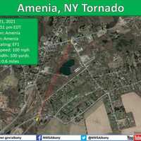
New Images Show Paths Of Tornadoes That Touched Down In Hudson Valley, Connecticut Two maps show the path of two tornadoes that briefly touched down in the region as a severe storm system swept through on Wednesday afternoon, April 21 The first tornado touched down in New York's Hudson Valley, in Amenia in Dutchess County, at 2:49 p.m., just south of the village, and moved north northeast into the village, said officials with the National Weather Service. The tornado started near the intersection of Powder House Road and Ohandley Drive and caused sporadic damage along its path length, the weather service found during an inspection of damage on Thursday, April 22. One ho…
National Weather Service Confirms Tornadoes Touched Down In Hudson Valley, Connecticut National Weather Service Confirms Tornadoes Touched Down In Hudson Valley, Connecticut National Weather Service Confirms Tornadoes Touched Down In Hudson Valley, Connecticut
National Weather Service Confirms Tornadoes Touched Down In Hudson Valley, Connecticut Click here for an updated story: New Images Show Paths Of Tornadoes That Touched Down In New York, Connecticut Two tornadoes touched down in the region as a severe storm system swept through on Wednesday afternoon, April 21. Late Thursday afternoon, April 22, the National Weather Service confirmed the twisters -- in Amenia, in Dutchess County, New York and in Bulls Bridge to southern Kent in Litchfield County, Connecticut. Both occurred between 2:49 p.m. and 2:51 p.m. Wednesday. The Amenia tornado was an Enhanced Fujita Scale - EF1 twister with an estimated peak wind speed of 100 …
Possible Tornado Touches Down In Hudson Valley Possible Tornado Touches Down In Hudson Valley Possible Tornado Touches Down In Hudson Valley
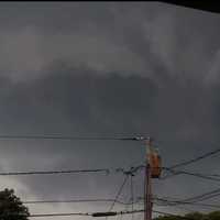
Possible Tornado Touches Down In Hudson Valley Crews from the National Weather Service are on their way to New York's Hudson Valley to assess damage from a storm that many say produced a tornado. The storms ripped through Dutchess County just before 3 p.m., on Wednesday, April 21, leaving in its wake downed power lines, split and toppled trees, and many without electricity. Brian Montgomery, a lead meteorologist with the National Weather Service, said specialized crews left Albany early Thursday, April 22, and are expected in the Hopewell Junction area around noon to view damage in order to determine if a tornado touched down and if so,…
PHOTOS: 1-Minute Twister Tears Through PA Town PHOTOS: 1-Minute Twister Tears Through PA Town PHOTOS: 1-Minute Twister Tears Through PA Town
Photos: 1-Minute Twister Tears Through PA Town A small tornado was to blame for the damage done in one Montgomery County town on Monday, the National Weather Service confirmed. Winds up to 70 mph came with the EF-0 storm that tore through a 100-yard path across Montgomeryville in approximately one minute's time. The half-a-mile wide twister touched down just east of Route 309 (Bethlehem Pike) near the onramp to the 202 Parkway at 3:47 p.m., the NWS said. Two small trees were uprooted on the northbound side of the highway. A twister touched down in Montgomery County, PA Monday.US National Weather Service Philadelphia/Mount Holly Ou…
New Tornado Touchdown Confirmed In Region, Bringing Total To Three New Tornado Touchdown Confirmed In Region, Bringing Total To Three New Tornado Touchdown Confirmed In Region, Bringing Total To Three
New Tornado Touchdown Confirmed In Region, Bringing Total To Three A new tornado touchdown from severe storm activity in the region on Thursday, Aug. 27 has been confirmed. The National Weather Service announced on Sunday, Aug. 30 that an  Enhanced Fujita Scale (EF) 0 twister touched down in Kent, Connecticut, near the Dutchess County border in Litchfield County, at 3:31 p.m. Thursday. An EF-0 twister, with winds of 65 to 85 miles per hour, is the weakest of six types of twisters. (See the scale at the bottom of this page.) The Kent tornado had maximum wind speed of 80 to 85 miles per hour, an estimated path of 75 yards, and path length of about…